


Resspass
 |
CH (AI), 9.4878°E, 47.3083°N | |||
 |
1309 m |  |
CH-AI-1309 | |
 |
Steinegg, 799m, 7km St. Martin, 980m, 4km Schluecht, 995m, 3km | |||
 |
Hard, 493m, 10km Schwammtobel, 1040m, 3km Forstseeli, 1195m, 2km | |||
 |
||||
 |


")
| |||
 |
roads and forest gravel roads, except under Forstseeli (steeper trail) | |||
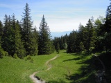
View from Resspass to the north-east, towards the Rhine valley | ||||
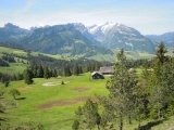
View from Resspass to the south-west with the Alpstein massif | ||||

From left to right: Fänerenspitz, Resspass and Forstegg, as seen from the slope of Kamor | ||||