


Chrinn
 |
CH (SG), 9.2902°E, 47.2105°N | |||
 |
1349 m |  |
CH-SG-1349 | |
 |
Oberlaui | |||
 |
Alt St. Johann | |||
 |
||||
 |


")
| |||
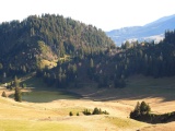
The small lake of Gräppelen and Chrinn | ||||
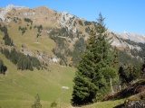
View from Chrinn towards Gamschopf and Säntis | ||||
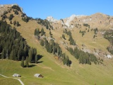
View from Chrinn towards Lütispitz and Gamschopf | ||||
|
CH (SG), 9.2902°E, 47.2105°N | |||
|
1349 m | |
CH-SG-1349 | |
|
Oberlaui | |||
|
Alt St. Johann | |||
|
||||
|
| |||
|
The small lake of Gräppelen and Chrinn | ||||
|
View from Chrinn towards Gamschopf and Säntis | ||||
|
View from Chrinn towards Lütispitz and Gamschopf | ||||