


Unterer Sattel
 |
CH (GR), 9.4849°E, 46.9197°N | |||
 |
1960 m |  |
CH-GR-1960 | |
 |
Vättis | |||
 |
Untervaz | |||
 |
||||
 |


")
| |||

Unterer Sattel, with the Ringelspiz massif (Piz Barghis) and the Calfeisen valley | ||||
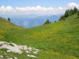
View to the east over the Rhine valley from Unterer Sattel | ||||