


Unterer Kriegersattel
 |
AT (VA), 10.1125°E, 47.2181°N | |||
 |
1999 m |  |
AT-8-1999 | |
 |
Lech, 1454m, 6km | |||
 |
Zug, 1510m, 4km | |||
 |
||||
 |


")
| |||
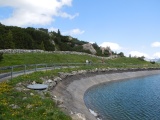
Reservoir Unterer Kriegersattel | ||||
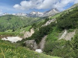
Sinkholes at Unterer Kriegersattel, with in the background from left to right: Rote Wand, Johannesköpfe, Hochlichtspitze and Braunarlspitze | ||||