


Widersteiner Furggel
 |
CH (GL-SG), 9.1574°E, 47.0306°N | |||
 |
2013 m |  |
CH-GL-2013 | |
 |
Engi, 821m, 8km Üblital, 1190m, 4km | |||
 |
Murg, 427m, 14km Merlen, 1089m, 8km Murgsee, 1817m, 1km | |||
 |
||||
 |


")
| |||
 |
easy up to Üblital but steep path (pushing) further up, detour over Gams not really easier because of the steepness of the gravel road; north side somewhat easier, largely cyclable up to the Murgsee | |||
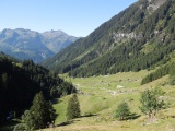
Üblital and the (steep) gravel road up to Gams | ||||
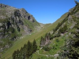
The hut and the pass of Widerstein as seen from Usserbergli | ||||

View to the south from Widersteiner Furggel | ||||

Widersteiner Furggel: Patrick's hundredth new pass in 2012 | ||||
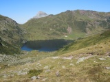
Murgsee and Murgsee Furggel as seen from Widersteiner Furggel | ||||