


Golrosa
 |
CH (GR), 9.744°E, 47.0316°N | |||
 |
2128 m |  |
CH-GR-2128 | |
 |
Grüsch, 638m, 23km Vordersäss, 1699m, 4km | |||
 |
Schiers, 660m, 20km Stägentobel, 1569m, 9km Pardutz, 1740m, 5km | |||
 |
||||
 |


")
| |||
 |
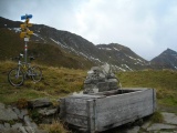
long climbs, pushing necessary uphill between Hintersäss (westside) and the Pass, also downhill between Hintercavell and Pardutz (east) | |||
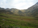
Golrosa as seen from Hintersäss (Vals, Prättigau) | ||||
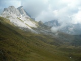
Golrosa, east side, with Kirchlispitzen and Drusenfluh (in the clouds) | ||||
Golrosa, right in the back Fadurer Fürggli | ||||