


Grimselpass
 |
CH (BE-VS), 8.3366°E, 46.5613°N | |||
 |
2165 m |  |
CH-BE-2165b | |
 |
Innertkirchen, 625m, 27km | |||
 |
Oberwald, 1368m, 13km Gletsch, 1759m, 6km | |||
 |
||||
 |


")
")

")
| Tour 1993 Tour 2010 Tour 2014 | ||
 |
road connection between the bernese Oberland (Haslital) and Oberwallis (Goms), important traffic during vacations and week-ends | |||

The lake of Räterichsboden as seen from the Grimsel dam | ||||

Grimsel lake and hospice | ||||

View from Grimsel over Gletsch and towards Furka | ||||
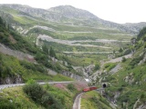
Climbing towards Gletsch, with the road up to Grimsel pass and the train on the old Furka railway | ||||

Gletsch and the Grimsel as seen from the Furka road | ||||

The laces of the Grimsel pass from Gletsch | ||||

Grimsel pass and Totesee | ||||