


Faninpass
 |
CH (GR), 9.6958°E, 46.8626°N | |||
 |
2212 m |  |
CH-GR-2212b | |
 |
Peist, 1334m, 9km Zerfalta, 1819m, 5km Muschgel, 2128m, 2km | |||
 |
Pragg-Jenaz, 709m, 22km Hinterberg, 1409m, 15km | |||
 |
||||
 |


")
| |||
 |
(noch nicht auf Deutsch übersetzt:) versant nord long et difficile, versant sud presque entièrement cyclable, mais avec passages pouvant être mouillés | |||
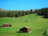
Barguns oberhalb von Peist | ||||
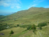
Faninpass, Seite Peist, bei Zalüenja | ||||
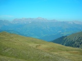
Faninpass, Seite Prättigau | ||||