


Illpass
 |
CH (VS), 7.6271°E, 46.2509°N | |||
 |
2482 m |  |
CH-VS-2482 | |
 |
Chippis, 565m, 29km Vissoie, 1204m, 16km Chandolin, 1979m, 6km | |||
 |
Susten, 624m, 17km Dörfji, 1435m, 8km Untere Illalp, 1821m, 5km | |||
 |
||||
 |


")
| |||
 |
(noch nicht auf Deutsch übersetzt:) route jusqu'à Chandolin puis bon chemin jusqu'au col, sentier avec longs poussages sur versant Susten | |||
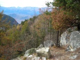
Zwischen Sousillon und Chandolin | ||||
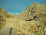
Der Illpass und der Schwarzhorn | ||||

Der Illsee vom Illpass gesehen | ||||