


Nanzlicke
 |
CH (VS), 7.9821°E, 46.2442°N | |||
 |
2447 m |  |
CH-VS-2447b | |
 |
Glis, 680m, 19km Mättwe, 1830m, 4km | |||
 |
Simplonpass, 2006m, 6km Hopsche, 2038m, 4km | |||
 |
||||
 |


")
| |||
 |
beautiful track, difficult or non-rideable parts, long on the side of the Nanz valley but possible to combine with Inneri Nanzlicke or Bistinepass | |||
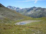
The little Straffelsee lake near Nanzlicke | ||||
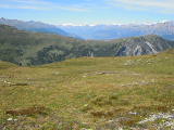
View towards Gebidum from Nanzlicke | ||||