
 MTB tour Les Crosets - Pas de Croisette - Pas de Chavanette - Les Crosets (18 July 2022)
 |
18 km |
| 770 m ^ | |
 |
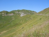
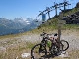
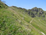
At Pas de Croisette, with the Dents Blanches mountains on the right 18-07-2022 10:22 6.8544°E, 46.1947°N, 1820m |
 |
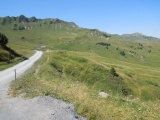
Pas de Croisette towards Champoussin 18-07-2022 10:23 6.8544°E, 46.1947°N, 1820m |
 |
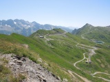
The Portes du Soleil pass while climbing from Les Crosets 18-07-2022 11:10 6.8358°E, 46.1942°N, 1910m |
 |
The Dents du Midi mountains as seen from Les Portes du Soleil 18-07-2022 11:20 6.8314°E, 46.1944°N, 1950m |
 |
From Les Portes du Soleil: Tour Salière, Mont Ruan, Dents Blanches and, closer, Croix de Culet 18-07-2022 11:21 6.8314°E, 46.1944°N, 1950m |
 |
Towards the valley of Morgins from Les Portes du Soleil, with the Cornebois, Bécor and Tête du Géant mountains 18-07-2022 11:23 6.8314°E, 46.1944°N, 1950m |
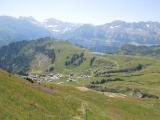 |
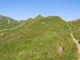
Planachaux as seen from La Colline des Crosets 18-07-2022 11:48 6.8272°E, 46.1908°N, 2030m |
 |
View towards the valley of Morgins from La Colline des Crosets 18-07-2022 11:50 6.8272°E, 46.1908°N, 2030m |
 |
View towards the Dents du Midi, Tour Salière and Mont Ruan mountains from Les Portes de l'Hiver 18-07-2022 12:06 6.8211°E, 46.1919°N, 2096m |
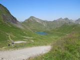 |
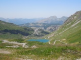
Las Vert (green lake) from Les Portes de l'Hiver (which name actually from the lake originates) 18-07-2022 12:07 6.8211°E, 46.1919°N, 2096m |
 |
Les Mossettes mountain from Les Portes de l'Hiver 18-07-2022 12:16 6.8211°E, 46.1919°N, 2096m |
 |
Near the Pointe des Mosettes mountain, with view on Val d'Illiez and Dents du Midi 18-07-2022 12:30 6.8175°E, 46.1897°N, 2170m |
 |
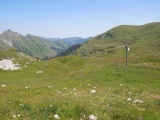
The Cuboré pass reveals the mountains Tour Salière and Mont Ruan 18-07-2022 12:59 6.8086°E, 46.1806°N, 2090m |
 |
The Pointe de Chésery and Pointe des Mossettes mountains as seen from the Cuboré pass 18-07-2022 12:59 6.8086°E, 46.1806°N, 2090m |
 |
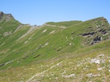
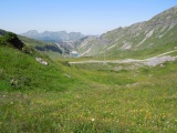
The basin of Cuboré as seen from the Vorlaz pass 18-07-2022 13:36 6.8053°E, 46.1789°N, 2205m |
 |
From the Vorlaz pass towards Pas de Chavanette and the Fornets mountain 18-07-2022 13:37 6.8053°E, 46.1786°N, 2205m |
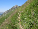 |
Path on a steep slope between the Vorlaz and Chavanette passes 18-07-2022 14:02 6.8058°E, 46.1756°N, 2160m |
 |
Vorlaz pass as seen from Pas de Chavanette 18-07-2022 14:12 6.8053°E, 46.1739°N, 2144m |
 |
Formet reservoir and the touristic resort Avoriaz as seen from Pas de Chavanette 18-07-2022 14:12 6.8053°E, 46.1739°N, 2144m |
 |
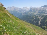
Multicolour flora at Pas de Chavanette 18-07-2022 14:13 6.8053°E, 46.1736°N, 2144m |
 |
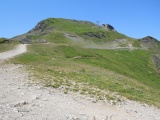
Pas de Chavanette 18-07-2022 14:18 6.8053°E, 46.1736°N, 2144m |
 |
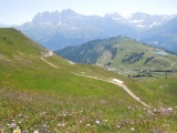
From the Bassachaux pass towards the Chavanette pass 18-07-2022 14:30 6.7983°E, 46.1681°N, 2093m |
 |
View over Avoriaz from Bassachaux pass 18-07-2022 14:30 6.7983°E, 46.1681°N, 2093m |
 |
Col de Cou (to the right) from Pas de Bassachaux 18-07-2022 14:30 6.7983°E, 46.1681°N, 2093m |
 |
The Val d'Illiez valley and the Dents du Midi as seen from Pas de Bassachaux 18-07-2022 14:30 6.7983°E, 46.1681°N, 2093m |
 |
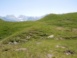
Basin of Les Pas 18-07-2022 15:03 6.8072°E, 46.1728°N, 2090m |
 |
Swiss slope of the Chavanette pass 18-07-2022 15:03 6.8072°E, 46.1728°N, 2090m |
 |
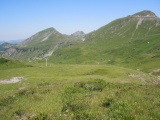
Planachaux, Croix de Culet and Dents du Midi mountains 18-07-2022 15:03 6.8072°E, 46.1728°N, 2090m |
 |
Col de Ripaille towards Les Pas 18-07-2022 16:03 6.8169°E, 46.1703°N, 1823m |
 |
Col de Saune in front of the Croix de Culet and Dents du Midi mountains 18-07-2022 16:25 6.8292°E, 46.1786°N, 1820m |
 |
Les Crosets as seen from the Saune pass 18-07-2022 16:28 6.8292°E, 46.1786°N, 1820m |