
 Tour 2024, stage 4: Praz-sur-Arly - Aravis - Croix Fry - Plan Bois - Nâves-Parmelan (25 August 2024)
| 1390 m ^ | |
 |
Flumet 25-08-2024 10:00 6.5197°E, 45.8208°N, 980m |
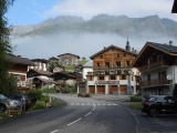 |
La Giettaz and the Aravis mountains 25-08-2024 10:24 6.4956°E, 45.8614°N, 1080m |
 |
Last curves between La Giettaz and the Aravis pass 25-08-2024 10:59 6.4733°E, 45.8719°N, 1440m |
 |
Ste-Anne chapel at the Aravis pass 25-08-2024 11:06 6.4650°E, 45.8722°N, 1486m |
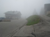 |
Croix-Fry pass in the fog 25-08-2024 12:02 6.4031°E, 45.8769°N, 1460m |
 |
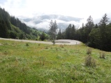
Manigod from the road up to Plan Bois 25-08-2024 12:55 6.3700°E, 45.8431°N, 1180m |
 |
Plan Bois pass as arriving from the east 25-08-2024 13:03 6.3611°E, 45.8400°N, 1270m |
 |
Plan Bois pass to the east 25-08-2024 13:08 6.3583°E, 45.8400°N, 1299m |
 |
Les Clefs 25-08-2024 13:29 6.3292°E, 45.8597°N, 700m |
 |
Voie Romaine from the shores of the Fier river up to Nâves 25-08-2024 14:06 6.2081°E, 45.9047°N, 550m |